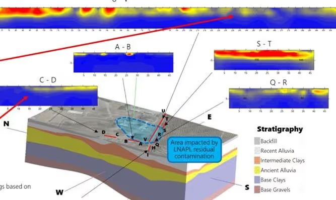
Monitoring Soil Pollution
Soil contamination is a hidden threat that can disrupt agriculture, endanger ecosystems, and contaminate groundwater. Traditional investigation methods are often invasive, time-consuming, and limited in spatial coverage.
Our Solution:
By analyzing electrical resistivity and induced polarization data, we detect polluted zones and provide actionable insights to guide remediation strategies.This non-invasive approach helps locate contaminants such as heavy metals, hydrocarbons, or leachates. Our solutions support environmental consultants, engineers, and decision-makers in prioritizing cleanup efforts and reducing long-term ecological risks.
Waste Disposal Site Monitoring
Improperly managed landfills and industrial waste sites can leak harmful substances into surrounding soil and water systems. Without continuous monitoring, leaks often go undetected until significant damage has occurred.
Our Solution:
-
Improperly managed landfills and industrial waste sites can leak harmful substances into surrounding soil and water systems.
-
Without continuous monitoring, leaks often go undetected until significant damage has occurred.
-
•Detect leaks in geomembranes or clay liners to ensure effective waste containment.
-
•Monitor leachate flow and distribution to support optimal biodegradation.
-
Our geophysical tools deliver reliable, long-term monitoring solutions to safeguard both the environment and public health.This continuous surveillance helps operators comply with regulations and respond quickly to anomalies. It also minimizes costly repairs, environmental fines, and reputational damage.
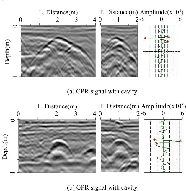
Locating Buried Structures
Buried structures such as ancient ruins, pipelines, or undocumented utilities can pose serious challenges during excavation or construction. Traditional digging can be costly, risky, and potentially destructive to valuable cultural or urban infrastructure.
Our Solution:
We use resistivity imaging and Radar to map hidden structures such as ancient walls, burial sites, or underground utilities, providing clear and accurate data to support excavation or construction projects.This method eliminates guesswork and reduces the need for invasive digging. It’s an essential tool for archaeologists, engineers, and urban developers looking to work safely and efficiently.